Tuesday, May 16, 2017

16 May 2017: Texas Panhandle, SPC Moderate Risk

                May 16th, 2017 was a day fraught with perils from Mother Nature. However, the horror of my experience was due to man-made errors. I learned an important lesson on this trip; don’t take car problems lightly.

                The morning began at our hotel in Pampa, TX. The SPC had upgraded their convective outlook to a moderate risk for the eastern half of the Texas panhandle into far western Oklahoma. The dryline had migrated east overnight. A new surface low appeared to be developing in far southwest Kansas, and it seemed as if it were going to move little throughout the day.

                Forecast models showed the largest activity breaking out down south near Childress. A large helicity swath crossed the Red River into Oklahoma. I decided early that this was going to be a logistical nightmare, as most chasers would flock to that region, and the river crossings were limited. My own forecast set me north of I-40 between Canadian and Wheeler.

                We arrived in Canadian, TX around late morning, and spent a fair bit of time at the local Dairy Queen. I continued to mull over weather data from that morning to fine-tune my forecast for the afternoon. Veteran storm chase Jeff Piotrowski joined us briefly and I discussed the setup with him. It looked like a textbook day for multiple tornadoes. We also took a little time to check out an old iron bridge that was a bit of a landmark.


                As the afternoon progressed, storms started to rise above the horizon. Skipping some nearby storms to the north, we planned to head south instead. The environment seemed better suited to tornadoes closer to I-40.

                The first scare of the day came when I turned the ignition key in my car. Nothing happened. Thankfully an auto shop was open next-door. The attendant there was gracious enough to step out and work with it for a few minutes. He got the car to start, and told us what he thought the problem was. After getting instructions on how to keep the car starting, we went on our way. We decided to head to Oklahoma City to get the car checked out after the day’s chase ended.

                Our forecast was on the mark. The southern storms grew rapidly, and soon tornado warnings were being posted. We were on the right road to intercept the best-looking storm on radar. We met the storm on highway 273, south of the town of McLean. Many other storm chasers were gathered here too. A mobile Doppler radar was on a nearby hill.

                Soon the southwest edge of the storm came into view. Low, dark clouds stretched across the southern sky. This apparently rain-free portion of the storm held a nasty secret though. Tennis ball sized hail slammed down on the car. I laughed anxiously at the sudden onslaught, hoping the windshield would stay intact.


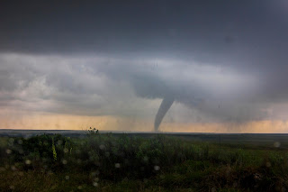
                During the barrage, a funnel stretched down from the clouds. It seemed to just hang there for the longest time, unwilling to descend all the way to the ground. Finally, it started to dance along the open prairie, narrow and delicate. After a few moments of teasing the Earth, it filled out, growing large and stubby.


                Rain started enveloping the tornado shortly after it grew larger. I made the decision to move up the road a few miles after it vanished into the rain. Once again, we turned the key, and nothing. Panic set in this time. We scrambled to figure out what was wrong. It seemed there was nothing we could do on the spot.

                To my surprise, the tornado emerged from the rain a few minutes later. It was long and spindly, in the final moments of it’s life. I stopped messing with the car for a few minutes to get some photos and video as it deteriorated.


                I called AAA for a tow. We sat on the side of the road as chaser after chaser passed us by until the road was empty once again. The ominous storm clouds rolled on to the northeast and sunlight returned.

                The tow truck arrived an hour and a half later.

                “Did you see the tornado?” asked the driver. I replied that I had.

                It was a mostly uneventful ride to Amarillo. News of a tornado striking the south side of Elk City, OK popped up on social media. Our driver mentioned that he had a brother in Elk City, and called to make sure he was fine.

                We dropped my car off at the Hyundai dealership in Amarillo and stayed in a hotel across the street. The car was diagnosed two days later. The starter had been staying engaged and burned out the entire ignition system. It was a quick fix, but cost me a grand. It was my most expensive tornado ever. That evening I discovered that the storm that had produced the tornado at McLean had also put down a large, rain-wrapped tornado very near Wheeler. The southern end of my target had panned out.


                But not all news was bad. The dealership took care of what they called a few recalls. It turns out those recalls amounted to an engine rebuild. About $3000 worth of work for free. At the end of the day, I couldn’t complain.

Monday, May 15, 2017

15 May 2017: Supercell, Stinnett-Spearman, TX

                Day one of my 2017 chase season began as we departed Joplin, MO. Christopher Strang was accompanying me for the second year. A look at morning data suggested a near repeat of the previous day’s weather. The dryline was lingering near Amarillo, and outflow boundaries from the previous day’s storms would provide a region for new development that afternoon. LCL height was well beyond risk for tornadoes, however.

                I decided not to rush. There was plenty of time to reach the panhandle by late afternoon. The drive across Oklahoma wasn’t noteworthy at all. I had been in touch with fellow chaser Matt Hunt over the previous couple of days. We decided to meet up if we had the opportunity. We ended up meeting at a Love’s off I-40 and 207. By this time, towers were starting to develop to the west.

                We took 207 north toward Borger. A cluster of cumulus were developing into a few scattered thunderstorm cells near Stinnett. After a brief look at the sky and radar in Borger, we continued north to Stinnett, stopping on highway 152 west of town.

                For the next hour and a half, small storms seem to cluster randomly in the area. There was no real organization in their development or movement. At 6:30pm local time, an organized supercell started to take shape just to the southwest of Stinnett. We moved back to 207 in time to see the updraft take on a very nice mothership formation. True to the forecast, the base was very high. Tornado formation still didn’t seem likely. The lack of chaser traffic also suggested limited tornado threat.

                As the updraft drifted northeast toward Stinnett, we decided it was time to adjust. Matt held back for a few minutes more. The plan at that point was to follow 207 as far as we could, as it took a northeast turn north of town. Soon we realized this plan wasn’t going to work out. The northeast jog in the highway ended up in the north end of the hook. We were stuck in heavy rain and small hail from that position.

                Matt caught up with us and we continued until we reached eastbound highway 281. We waited out some moderate sized hail there for a few minutes, then started east. There we crossed a swath of dense hail, still melting on the road. Eventually 281 turned north and connected with highway 51. We finally were able to get ahead of the updraft region again. The storm was occluding at this point, rain shafts showing dramatic outward flow away from the base.

                We parked with Matt at a turnoff a few miles farther east. He set up a DSLR for time-lapse, and I shot several minutes of video from this spot. The lightning at this stage was impressive, set against the low sun to the west. Less impressive were the swarms of mosquitos in this area. We regretted not having repellant at this point, and vowed to pick some up the next morning.

                The storm looked to be in it’s death throes as time passed. We considered heading to Pampa for the night. As we headed east again, the storm started to reorganize, and a healthy updraft re-emerged. We stopped again briefly where the highway took a jog to the north. Some of the best lightning of the day occurred at this point. I shot a few more minutes of video before calling it a night. It was time to prepare for what we hoped to be a much more interesting day.


May 15 2017 from Adam R Davis on Vimeo.

Tuesday, February 17, 2015

BRRRRRRR....

     It took a while longer than last year, but the hellish cold has returned with a vengeance. Good ol' Rex block is going to keep things stuck for a while. Here's hoping the late start doesn't mean an even later start to spring than last year. Not that we had a transitional season last year. I think we can say we went from winter, to 3 months of really weak summer (at least for the northeast) and on to fall.
     This semester, I'm taking field production. It's a class where we, as students, create news packages from the field, rather than a studio. Of course, I'm making a story about the return of icy/snowy hell for 2015. I will share the finished package here if possible. I'm also taking Earth Science as a gen ed. I'm enjoying it a great deal so far... but that's kind of expected from a nature-addict like myself. It's a pre req for meteorology, which I plan to take the next semester it's offered in.
     I really need to keep this updated better. To close, here's a little gag cartoon.

Thursday, August 28, 2014

Another Year of Failure

2014 is another severe weather bust for me. The one week I had off for chasing was dominated by a gigantic ridge. I didn't even leave home. I think the biggest insult this year were the pair of tornadoes that touched down only one county away on my birthday. I was in bed sick the whole time. 2015 had better be spectacular. For now... back to school.

Tuesday, September 24, 2013

First Post

Just getting things started here. Don't really have much to say right now. I largely missed out on the 2013 storm chasing season due to moving. It's been a very storm free year for me so far. Temperatures are starting to cool now, and I'm beginning to see changes in the leaves. We've actually had a couple VERY early frost advisories here in PA. I'm accustomed to feeling these temperatures in late October. But this has been a very cold year overall.